Fluid Mechanics of Hurricanes
The destructive power of a major hurricane is unlike anything else on Earth with the proven capability to significantly damage the United States economy and energy sector, destroy entire regions and kill thousands of people even in the modern era. The landfall of Hurricane Maria (2017) in Puerto Rico is a prominent, recent example of the massive disruption a major hurricane can cause. Maria’s strong winds caused annihilation to Puerto Rico’s transportation, agriculture, communication and energy infrastructure with estimates of ~ 3,000 deaths and over 90 billion dollars in damages. Many of the deaths were attributed to the nearly complete destruction of the power grid and a compromised water supply, even several months after the event.
Unfortunately, as the climate system continues to warm, recent research suggests that intense hurricanes will likely become more common, produce more flooding rainfall and last longer even after landfall. The accurate prediction of hurricane intensity and associated hazards has remained largely stagnant with large forecast errors still present today, especially for the rapid intensification process. To improve dynamical models and develop a holistic understanding, the GFD group performs fundamental research on the physics of turbulence, convection and the vortex as well as numerical model development.
Examples of the basic turbulence work conducted in the GFD group are described below:
We are studying the physics of the hurricane rapid intensification (RI) process with a specific focus on the lifecycle of turbulent, buoyant convection and the scale interaction processes that this forcing initiates in the inner-core of the system. Advanced, high-order computational models that have optimal numerical properties for simulating turbulent flow are used to understand the physics and compare to community models. The animation below shows a preliminary large eddy simulation (LES) of the hurricane RI process at a constant grid spacing of ~ 60 meters over the domain shown. The vortex is embedded in a much larger domain (~ 800 km on a side) and only the inner domain that contains the core of the vortex is shown. The developing eyewall morphs into a highly asymmetric structure with the appearance of mesovortices at the eye-eyewall interface and smaller-scale turbulent structures in the eyewall.

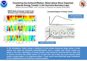
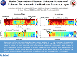
We also have a significant portfolio of airborne radar measurement work that has revealed fundamental concepts of energy transfer and turbulent structure in the hurricane boundary layer as described in the highlight slides below. This work is partially funded by the NOAA Weather Program Office (WPO) under the Next Generation of Mesoscale Weather Observing Platforms solicitation and the NASA Weather and Atmospheric Dynamics Focus Area (WADFA).


Wildfire Plume Dynamics and Effects on Climate
Recent observations of megafires in California, British Columbia and Australia have sparked new questions about the two-way coupling between the troposphere and stratosphere that impact climate. These large wildfires and the pyroconvection they produce, can transport large plumes of smoke aerosol into the lower stratosphere where they rise even further due to self-lofting effects and spread across the planet, resulting in stratospheric residence times of many months to years. The long lifetime and extensive spatial coverage of these plumes in the stratosphere can produce substantial radiative forcing of the climate system with short- and long-term effects that are not well understood. In an extreme case, where nuclear war between nations could potentially transport massive amounts of smoke aerosol into the stratosphere, significant global cooling can take place in a process known as “nuclear winter”.
Physics of Precipitation Bands in Extra-Tropical Systems
Banded structures in extreme weather systems are generally turbulent perturbations to a balanced, background flow that can organize and concentrate variables such as moisture, momentum, and energy. The concentration of these variables can lead to multiple intense bands of mixed-phase precipitation that are difficult to measure, model and predict with significant consequences for society in the energy and travel industries. The current understanding of the physical processes controlling the formation and evolution of these precipitation bands and their representation/predictability in numerical models is limited.
In this work, airborne and spaceborne remote sensing measurements along with large-eddy numerical simulations are being used to advance the understanding of the physics of banded structures in extra-tropical cyclones. The measurement aspect focuses on radar data collected during the Investigation of Microphysics and Precipitation for Atlantic Coast-Threatening Snowstorms (IMPACTS) field campaign along with supporting satellite data. The modeling aspect provides a testing ground for airborne simulation studies and a mechanistic understanding of the banded structures using a dynamical budget methodology.